Dry start to the year in southeast Queensland
Summer and early autumn is the wettest time of year in Queensland, but the first five months of 2023 have been uncharacteristically dry in the southeast and southern inland areas of Qld. The image below highlights (in orange and yellow colours) areas where accumulated rainfall anomalies are more than 100mm below average for this time year – southeast Qld and adjacent ranges, plus the southern inland, clearly stand out. This is despite recent rainfall in the area over the last week or so.
Image from Bureau of Meteorology
La Nina (a climate state that supports more moisture in eastern Australia and higher rainfall) events over the last couple of years have delivered high rainfall to the area and it’s thanks to this antecedent rainfall that the dam levels that supply Brisbane are still high and soil moisture in the region is holding up.
However, we now approach Qld’s dry season – winter and early spring – which is famous for sunny skies, mild temperatures, and traditionally little rainfall. El Nino (a dry and warm climate state) also threatens to develop in the next few months and tends to have a drying effect across much of Australia.
What are the potential implications of the low rainfall so far this year? When coupled with El Nino and a drier and warmer winter and early spring? For southern and southeast Qld, this could mean an early start to the bushfire season (typically onset is around August), as well as the risk of a more active season. Bushfires can damage powerlines and other power infrastructure, resulting in forced outages if fires are intense enough. Strong grass growth in recent months contributes to fire risk.
Gardeners may find their plants require more watering, particularly in spring, and this may place pressure on dam levels and potentially lead to water restrictions. Households may require water efficient equipment (such as hoses) as a result.
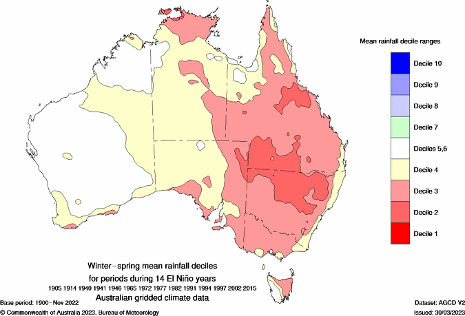
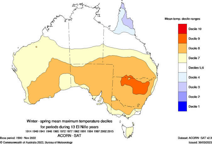
But how dry could it be? The images below (from the Bureau of Meteorology) show the connection between El Nino and drier weather for Qld and warmer day-time temperatures during the winter and spring months, by way of rainfall deciles. Deciles are a way of ranking values in a data set, with deciles 5-6 being near the average of the data set (and decile 9 being very much above average – the top 10% of data, and decile 1 being very much below average – the lowest 10% of the data). It highlights that inland areas have stronger odds for drier conditions; about 7 out of every 10 El Nino winter-spring periods are drier than average for inland parts of southern Qld, for Brisbane though the odds are more like 6 out of 10 El Nino winter-spring periods are drier than average. Note that daytime temperatures are also often warmer.