
MetraWeather Insights Platform
No more weather surprises.
A high-resolution weather delivery tool designed for business planning and operational management.
MetraWeather Insights Platform allows you to access, monitor and utilise powerful apps and datasets to make safer, faster and more cost-effective decisions.
Insights Platform Apps:


Adverse and uncertain conditions are costly, don't let them affect your business.
MetService real-time weather and marine information can increase safety, save time and save you money.
Dashboards
Configurable & customised
Customisable dashboards for conditions that matter to you. Tailored to your specific needs, Dashboards put everything required to make on-time operational decisions in plain sight.
Widgets
Dashboards provide a wide range of widgets - bar, line and rose charts, maps, tables, threat matrices and more. All widgets are interactive and update automatically with latest data.
Integrate easily
Dashboards can be integrated into your existing platforms or operational dashboards without costly technical development.
Configurable to your needs
Dashboard layouts are highly configurable and can be tailored to a wide range of screen sizes. From displaying on the video wall of an operational command center to a single, or partial, monitor of an individual workstation.
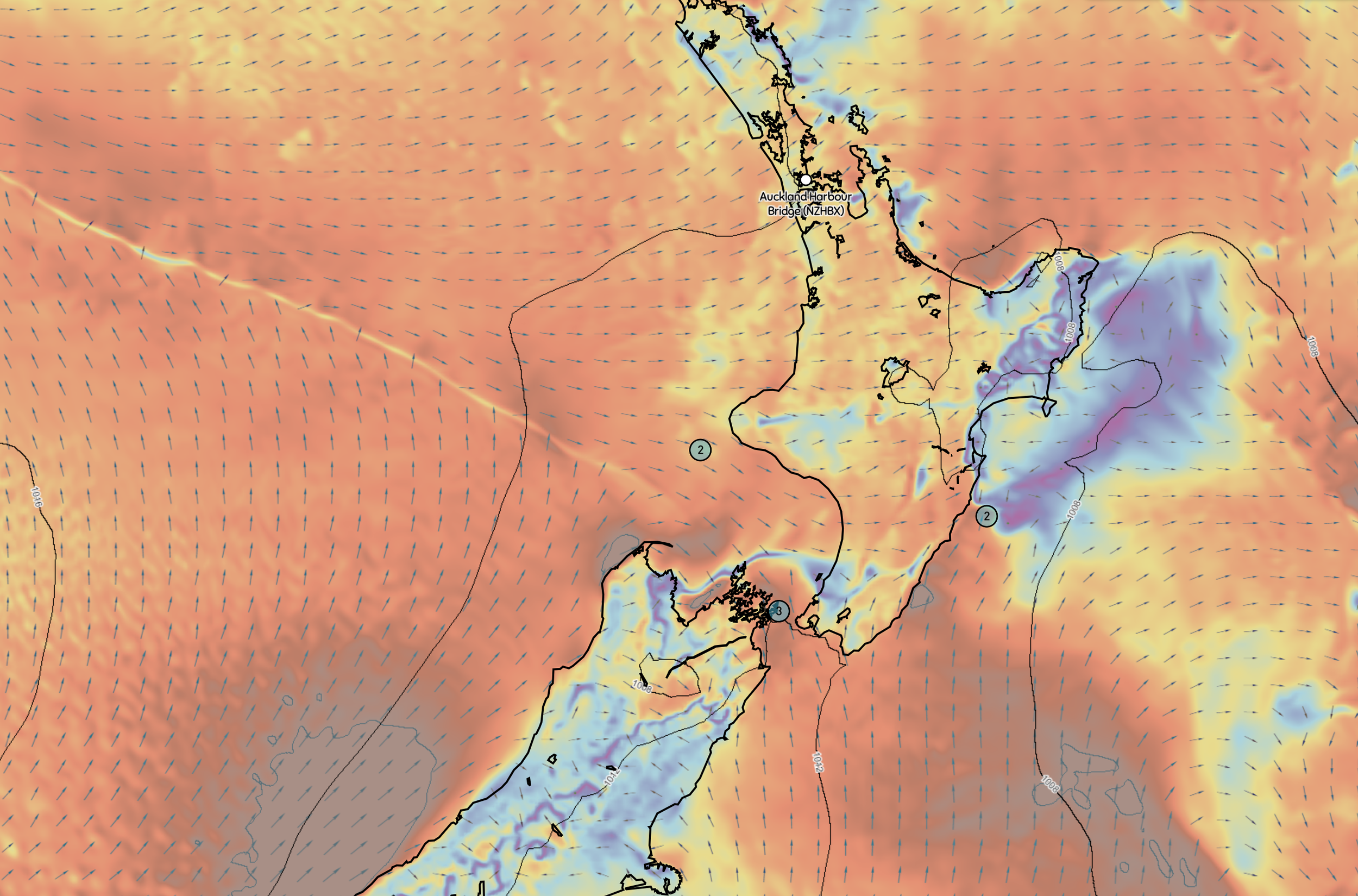
Forecast
Real-time forecasts and observations.
Access high-resolution modelling and observation data as interactive maps or view detailed reports for your sites.
Operational Planning & Management
Hourly forecast data up to 7-days ahead and long-range guidance with custom data resolution. Access your reports via the Insights Platform, any time you need, or have them scheduled to be sent to you by email. Forecasts are updated automatically, so you will always have the latest information.
High resolution models.
Atmospheric, wave and hydrodynamic forecasts for your specific location.
Our custom modelling builds on industry standard models, tailoring them to customer needs. Our high-resolution models allow us to accurately forecast conditions at scales ranging from global to hyper-local (e.g. a berth within a port).
Customisable reports
Site Reports can include custom threat matrices with safety limits specific to operations in your area.
By aligning your operational requirements with forecast thresholds you can provide your team simpler, impact-based guidance on whether it is safe to operate.
Real-time observations
Forecast provides access observations from our network of weather stations, buoys, radars, lightning detectors and more through Insights Platform. Easily compare forecasts with actuals so you can be confident the models are performing well.
In addition to the MetService observation Network, Insights Platform allows you to integrate private observation data from your own stations.
Hindcast
Localised historical weather.
Access high-resolution modelling and observation data as interactive maps or view detailed reports for your sites.
Summary statistics
Ambient and extreme wind and wave summary statistics (monthly and annual) are freely available at each node for several model domains.
Visualise summary statistics spatially with specific map layers.
Time series of metocean parameters
Download time-series of ocean and atmospheric parameters at specific locations, including 2D wave spectra and kinematics for anywhere on the planet.
Our numerical models generate accurate historical wind, wave and current data for any location on Earth. View our existing datasets or contact us to discuss getting historical weather data for your desired location.
Key baseline information
Access gridded data of metocean parameters in different data formats.
Generated by our team of expert scientists using a suite of in-house atmospheric and oceanographic models, our historical data archives reach back decades.
These datasets offer key baseline information for project scoping, offshore and coastal design, project planning and environmental impact assessments.

Particle Tracker
Configure, run, and visualise particle tracking simulations.
Makes use of hydrodynamic, wave and wind modelling to predict the movement of objects and particles in the ocean.
Versatile
Particle tracker is useful for scientific research, biosecurity monitoring, coastal engineering consultancy, search and rescue operations, and oil spill responses.
Configure simulations to track a wide range of particle types including oil spills, sediment, lost persons/objects, invasive species, marine larvae and plastics.
Multiple time scales
Particle Tracker can make use of Hindcast, Nowcast and Forecast data to provide tracking for any time frame. Simulations can also be configured to operate in reverse to provide backtracking of where something came from.
High-resolution models
Particle Tracker makes use of lagrangian particles, forced by ocean hydrodynamics, waves and atmospheric processes, modelled using our industry standard custom high-resolution models.
Models and observations
Numerical models available in Insights Platform:
Global Forecast System (GFS)
A weather forecast model created by the National Centers for Environmental Prediction (NCEP). It generates data for various atmospheric and land-soil variables, including temperatures, winds, precipitation, soil moisture, and ozone concentration. GFS models prove modelled atmospheric conditions at global scale (~26 km resolution).
European Centre for Medium-Range Weather Forecasts (ECMWF)
Sophisticated atmospheric models that describe the dynamic behavior of the global atmosphere. ECMWF models providing modelled atmospheric conditions at global scale (~9 km resolution).
Weather Research and Forecasting Model (WRF)
A numerical weather prediction (NWP) system designed to serve both atmospheric research and operational forecasting needs. Our in-house WRF models provide high-resolution prediction of atmospheric conditions in areas of interests (up to 300 m resolution).
Regional Ocean Modeling System (ROMS)
A 3D primitive equations ocean model using hydrostatic and Boussinesq approximations. Essentially, the model calculates the solutions for sea surface height, 3D currents and 3D temperature and salinity fields for the given forcing fields and boundary conditions.
Semi-implicit Cross-scale Hydroscience Integrated System Model (SCHISM)
A prognostic finite-element unstructured-grid model designed to simulate 3D baroclinic, 3D barotropic or 2D barotropic circulation. This model allows us to resolve hydrodynamic and wave conditions in highly complex inshore areas.
Mercator Hydrodynamic Models
Sophisticated tools developed by the Mercator Ocean organization. These models simulate the dynamic behavior of ocean currents, temperature, salinity, and sea level.
WAVEWATCH III (WW3) with Spherical Multiple-Cell (SMC) grid integration.
WW3 is a third-generation wind-wave model initially developed at NOAA/NCEP and with the in-house integration of SMC grids it supports flexible domain shapes and variable resolutions using unstructured grids. As such, our SMC configurations reduce resolution of the global wave model to 40 km in the open ocean to either 20km or 10km for areas with depths < 70 m and in areas of interest.
Simulating WAves Nearshore (SWAN)
A third-generation ocean wave propagation model which solves the spectral action density balance equation initially developed by Booij et al., 1999. We run 213 operational SWAN models available in the Insights Platform allowing us to predict wave conditions at up to 40 m resolution at various locations worldwide.
Bespoke and machine learning models
ePD/Dlite Forecast Models
Multi-model probabilistic forecasts that considers forecasts from several deterministic and ensemble models as well as observations to create an overall probabilistic forecast that is generally more accurate than any of the deterministic forecasts. ePD/Dlite are often used to fine-tune wind and temperature predictions.
Lightning Prediction Algorithms
Returns the near-future risk of lightning strikes at a given location.
Infragravity Wave (IG) or Long Wave Modelling
Specific forecast using Statistical post processing (SPP) or machine learning.
Statistical Post Processing (SPP) or Machine Learning.
Leveraging cutting-edge techniques, our team of skilled atmospheric and oceanographic modelers can effectively address a wide range of conditions. Feel free to reach out if you’d like to explore this further.
Observational data
MetService Automatic Weather Station (AWS) network.
Himawari and NASA satellite data.
Lightning Detection Network (New Zealand and global cover).
Rain radar (NZ and Australian cover).
We can work with you to integrate your organisation's private observational data to your personal Insight’s Platform account.
Models running now:
Not what you’re after? Contact us to discuss custom domains.
Get in touch
Contact our team to find out how we can help you make better business decisions.
Or email: InsightsPlatform@metraweather.com
Frequently asked questions
-
Insights Platform is designed for marine users and business who need accurate and easy to understand meteorological and oceanographic information to make key decisions.
-
MetraWeather are experts in both meteorological and oceanographic modelling. Forecasts are verified internally and independently to ensure the highest level of accuracy on an ongoing basis.
-
Business services start from AU$1,320 per month